
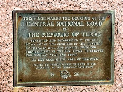
Central National Road marker north of Greenville on US Highway 69
Early 19th Century travel was truly 3-D: difficult, dirty, and dangerous. Yet our ancestors took to the roads, such as they were, for numerous reasons. Some were looking for a new start, others left worn-out land behind, and some were a few steps ahead of the bill collector, while another group simply left a nagging wife and family obligations behind. Whatever the reason, a smooth open road did not await them.
On February 5, 1844, the legislature of the Republic of Texas authorized the construction of the Central National Road to run from a point 2500 feet north of the Old Red Courthouse in Dallas to the village of Kiomatia in Red River County. The distance was 129.5 miles. Major George W. Stell was appointed surveyor with five commissioners and various chain carriers and aides. All were compensated in land. The road was surveyed and cleared in thirty days; however, no roadbed was ever prepared.
The original intent was to provide those settlers in Red River, Lamar, and Fannin Counties of northeast Texas with suitable access to the new capital at Austin. In addition, the Central National Road would serve as an international highway connecting the United States with the Republic of Texas. This new road abruptly ended at the point where the Red River was no longer navigable.
Opposite the end of the Central National Road on the northern bank of the Red River stood Fort Towson. It was at the termination of a military road that connected it to Fort Gibson, also in the Indian Territory, and Fort Smith in Arkansas. Once the Central National Road connected to the military road by ferry, it offered a means of entry into the fertile lands of the Republic of Texas for incoming emigrants.
The Central National road ran past Barnes Bridge Road to the present site of Heath before turning north, only to pass present day Rockwall to the east. From there it passed through the eastern portion of what is now Collin County. About two miles south of Highway 380, the Central National road entered future Hunt County. It ran northeasterly, crossing Cow Leach Creek where Kellogg is today.
At that point the road turned north to avoid Black Cat Thicket, a notorious landmark filled with wild animals and wild men. After circling the thicket, the road angled northeast, crossed the South Sulphur River near Webb Hill and continued in a northeasterly direction through Ladonia, Pecan Gap, and Paris before its termination on the banks Red River in Red River County.
Two years later, after Texas annexation, the new state legislature created three new counties along the Central National Road, Dallas, Hunt, and Collin. The road missed the county seats of Greenville and McKinney. In less than ten years, Fort Towson was abandoned by the United States Army and given to the Choctaw Nation. The dream of an international road into Texas was no longer applicable.
Ambassador Fletcher Warren, a native of Wolfe City, wrote in the application for the Central National Road historical marker at Kellogg that the road was widely used by residents of the northwest quadrant of Hunt County. That it missed the county seat was a detriment to the road. Yet, it was a viable local road in all the counties it passed through.